Welcome to visit BHC Navigation Co., Ltd.
   
        Home       Products       Maps and Accessories        Support        News        Contact us        About BHCnav   
Home > Products > NAVA handheld GPS > NAVA F60
  NAVA 110 Land Measurement
  NAVA 200
  NAVA 300
  NAVA 400
  NAVA 600
  NAVA F30
  NAVA F60
  NAVA Pro F70
  NAVA Pro F78

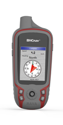
NAVA® F60
NAVA® F60 is an ideal rugged GPS and GLONASS receiver for a large range of applications from agriculture, forest, surveying, mining and more outdoor works...
>> Fully featured with 3-axile, Electronic       Compass, Barometric Altimeter and       Thermometer
>> 2.2" QVGA, 240X320 pixels, transflective color       display readable under sunlight
>> Supports GPS and GLONASS
>> Worldwide basemap preloaded, and also       supports Vector map (city detail map), DEM       map and Raster map
>> Multiple GPS data formats to share, including       GPX, SHP, MIF, CSV, KML, DXF, and TXT


   Quick Links
   >>Manuals
   >>Map
   >>FAQs
Physical & Performance:  
Unit dimensions, WxHxD: 5.7x12.9x2.8cm
Display resolution, WxH: 240×320 pixels, QVGA
Display size, WxH: 2.2''
Display type: Transflective TFT, 65K colors
Weight: 113g (without battery)
Battery: 2×AA; Lithium Battery
Battery life: 2xAA (up to 15 hours), Li-ion (up to 25 hours)
Waterproof: IPX7
High-sensitivity receiver: Yes (56 parallel channels)
Interface: USB and NMEA 0183 compatible
Maps & Memory:  
Basemap: Preload Worldwide basemap
Ability to add maps: Yes
Built-in memory: RAM: 128MB, Flash Storage: 4GB
Accepts data cards: Yes (microSD™ card 32G)
Waypoints/favorites/locations: 3000
Routes: 200
Track log: 400 saved tracks, 10000 points
Features:  
Automatic routing: Yes
Electronic compass: Yes
Barometric altimeter: Yes
Thermometer Yes
Geocaching-friendly: Yes
Custom maps compatible: Yes
Outdoor GPS games: Yes
Hunt/fish calendar: Yes
Sun and moon information: Yes
Area calculation: Area and Perimeter Calculation
Custom POIs : Yes
Google data compatible: Yes
AVG: Yes
Calculator: Yes
PC Support Software:  
NAVA GPS Office (NGO): Lets you manage and export & import your waypoints, tracks and routes in multiple GPS data formats, including GPX, SHP, MIF, CSV, KML, DXF, and TXT on your PC.


   Series
   >>NAVA 110
 
Brochure for NAVA F60 and F30


                        Company                   Products                   Maps and Accessories                   Support
                        About BHCnav                   NAVA Handheld GPS                   Maps                   FAQs
                        Become a Dealer                   SPORTA Cycling GPS                   Accessories                   Return and Warranty
                        Dealer Locator                   GISA GIS Data Controller                     Download
                        Contact Us                   GISA Tablet PC    

Site Map      •      Privacy Policy      •      Terms of use      •      Copyright © 2004-2014 BHC Navigation Co., Ltd. All Rights Reserved

Facebook/BHCnav
Twitter/BHCnav
Linkedin/BHCnav
Youtube/BHCnav